GPS, SatNav, Garmin, Magellan, TomTom, iPhone Maps, Android Maps … all have emerged to replace the now antiquated folded paper maps in glove-compartments the world over. However, not only has in-vehicle navigation revolutionized the trip to grandma’s house, but GPS devices have become a critical part of logistics monitoring, disaster response, traffic monitoring and a host of other civil and military applications. Therefore, it has become very important that organizations who use GPS for daily operations understand the impact that city geometry (or “urban canyons”) can have on a system’s ability to accurately locate vehicles in dense cities. Thankfully, AGI software provides analysis tools out-of-the-box to help users understand the complex system variables that can make or break a satellite navigation (SatNav) system under these difficult conditions.
Overview Video of GPS in Urban Environments
To understand this problem, it is important to start from the basics:
How does GPS work? The
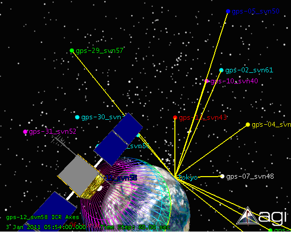
Global Positioning System (GPS) is a constellation of 30+ satellites which each circle the Earth every 12 hours at an altitude of 20,340 km (12,640 mi). Each satellite constantly broadcasts a unique signal toward the Earth which includes the satellite’s location and the time the signal was sent. When receivers on a GPS device tune into these signals, they calculate the delay from when the signal was sent to when it was received to calculate a distance (called a psuedorange) from the transmitting satellite. A GPS device needs to acquire at least four different signals in order to then estimate its latitude and longitude position and display that position on a map. Generally speaking, the more satellite signals the device can receive, the more accurate the position estimate will be. Since each satellite is broadcasting a signal that covers a large part of the planet’s surface, the signals transmitted by the satellites are very weak and are therefore extremely vulnerable to blockage from buildings and terrain.
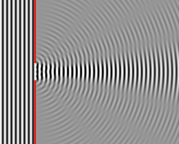
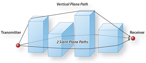
However, since all electromagnetic signals propagate like a wave, signals diffract around and reflect off certain surfaces such as the sides of buildings. This creates for a very complex signal environment that is different in every city in every part of the world every minute of every day! AGI's
STK software product accurately simulates the orbits of any type of satellite including imaging satellites, communications satellites and even navigation satellites like GPS and GLONASS, as well as vehicle motion of cars, ships and aircraft too. The
STK/Communications add-on models a wide array of RF-spectrum simulation including power, frequency, modulation, filtering, radiation patterns (gain) and path losses such as atmospheric absorption, system noise, interference sources and a multitude of other variables. Additionally, users can model the dominant signal propagation effects of urban geometry with the
Urban Propagation extension for STK/Communications which was developed in cooperation with AGI Product Partner
Remcom. Finally,
STK/Coverage performs signal analyses to understand the effects of a navigation system over individual vehicle routes, road networks or entire geographic areas for a comprehensive understanding of system performance given unique geographic and architectural constraints.
With AGI software products, users can analyze the unique effects of site-specific GPS performance such as:
- satellite availability
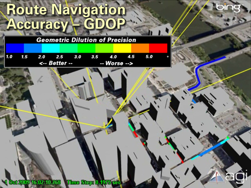
- dilution of precision
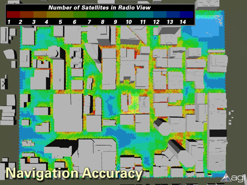
- navigation accuracy
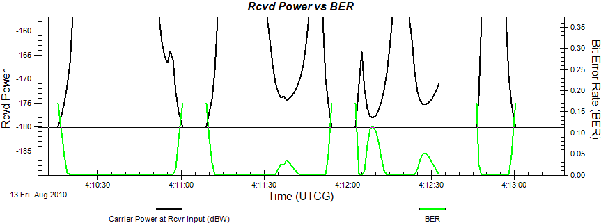
- individual signal strength
- benefits of augmentation systems (psuedolites, etc.)
- signal interference
- and many others
Example STK Graph:
Finally, STK’s rich and accurate 3D visualization environment allows for an easy understanding of the implications of the detailed reports and graphs provided with STK.
Below are a few samples to show the dramatic effects that dense urban structures can have on GPS navigation. The complex building geometry is coupled with STK’s high-fidelity RF physics models to create a uniquely robust simulation, test and evaluation environment for rapid analysis of urban GPS performance. There is typically a great amount of time and expense involved in fielding and testing SatNav systems in urban environments. Many organizations have
documented significant time savings and mitigated project risk by using AGI’s validated STK software for virtual system design and validation. Whether designing a new system, deciding to purchase a system or testing a system in a new environment, STK is a perfect system analysis tool to help reduce risk and cost in meeting the required system specifications.
Resources:
 Urban Propagation