Modeling and Analyzing Unmanned Aerial Systems (UAS) with Systems Tool Kit (STK)
- Oct 2, 2020
- Blog Post
-
 Urban Propagation
Unmanned aerial systems (UAS) are cheaper and easier to produce, maintain, and deploy than ever before. While these systems represent a potential boon for distribution and connectivity, they also pose a serious threat. The proliferation of these systems must be met with transformations in the way that they are designed and their missions are planned. Paramount among these transformations is the use of high-fidelity digital prototypes to model your UAS and Counter-UAS (C-UAS) infrastructures.
Digital mission engineering (DME) tools – such as Systems Tool Kit (STK) – enable you to model the individual aspects of your UAS or C-UAS systems. STK gives you the flexibility to model all the what-if scenarios that may arise from a rapidly scaling and dynamic UAS threat landscape. Here are some of the DME capabilities in STK:
- Aircraft vehicle modeling and route design – model routes for aerial vehicles in complex environments with detailed flight plans and pre-built or custom flight patterns and maneuvers. You can also define specific aerodynamic and propulsion characteristics for a wide range of aircraft, including small battery-powered rotorcraft.
- Communications – model antennas, receivers, and transmitters at adjustable levels of fidelity to analyze RF communication quality and produce link budget reports. You can also include interference sources and environmental factors that may result in link degradation.
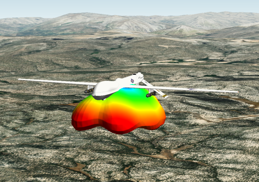
- Radar – model antennas, radar systems, and the radar cross section of targets at adjustable levels of fidelity. You can include the impacts of jamming and environmental factors to evaluate probability of detection and other metrics of effectiveness.
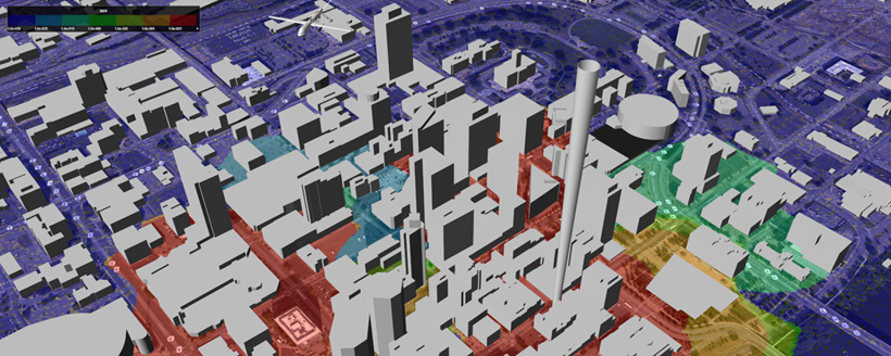
- RF Propagation Models – choose from built-in models for environmental losses (e.g., rain, cloud, atmosphere) or import your own models. Specialized modules enable you to model RF propagation through urban environments (with building models) and over irregular terrain, to capture non-line-of-sight effects.
- Radiometric Imaging – model the performance of electro-optical and infrared sensors for detecting, tracking, and imaging in a UAS management or detection system.
- 2D/3D Coverage and Volume Analysis – create grids of large areas of interest to see how systems perform over your selected region. This can reveal weak points, enabling you to optimize asset location and reliability.
If you want to learn more, join AGI at the AUVSI XPONENTIAL 2020 virtual conference and the C-sUAS Symposium this month. We’ll be happy to take you on a deep dive about how STK’s modeling capabilities and physics-based environment are vital to developing the central infrastructures of UAS and C-UAS systems and operations. Please click the links to register for these events, and watch the video below for more information on C-UAS analysis.
Author